
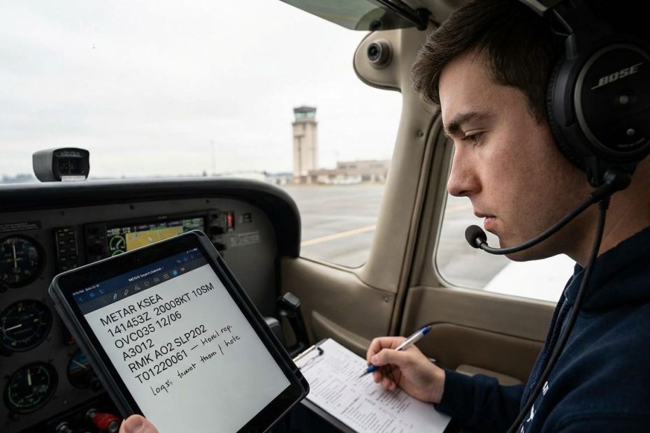
A METAR tells you what is happening at an airport right now, using a compact, standardized code that you can decode left-to-right in predictable chunks. When you can read it quickly, you stop guessing about wind, visibility, ceiling, and weather hazards and start making cleaner, safer go or no-go calls.
This guide shows you how to read a METAR at the speed you need in the cockpit, without skipping the details that matter for takeoff, landing, and decision-making. You’ll learn a repeatable scan method, how to translate the “big ticket” groups into operational meaning, and how to treat remarks as useful data rather than noise.
How Do You Read A METAR Step-By-Step (In Plain English) If You’re A New Pilot?
Read a METAR in the same order it is written, and force yourself to extract a decision from each group. The standard flow is station and time, wind, visibility, weather, clouds, temperature and dew point, altimeter, then remarks. METARs are generally issued hourly at reporting locations, and you should treat them as “current conditions” rather than a forecast.
Start by building a cockpit habit: one pass for legality, one pass for practicality. The legality pass checks if the conditions satisfy your operating rules, your aircraft equipment, and your personal limits. The practicality pass checks whether the numbers are stable enough to manage workload on departure, in the pattern, or on an approach, especially when the wind is gusty or the visibility is degraded by precipitation or haze.
Use a structured scan that never changes. Identify the time group and convert it into “how fresh is this observation,” then look at wind and ask, “What is the crosswind and gust spread for the runway I plan to use.” Move to visibility and ask, “Would you accept this in the pattern if something forces a tight return.” Move to ceiling and ask, “Does the lowest ceiling create a hard limit on maneuvering or an approach requirement.” Temperature, dew point, and altimeter finish the core, and remarks become the tie-breakers when conditions are close to your limits.
When you train this method, you stop getting stuck decoding every character. You decode only what changes the plan. That is how experienced pilots read METARs quickly, and it is how you should train from day one.
What Do Wind Groups Like “33015G25KT” And “180V240” Actually Mean For Takeoff And Landing?
The wind group gives direction and speed, usually in knots, with optional gusts and optional variability. “33015G25KT” reads as wind from 330 degrees at 15 knots, gusting to 25 knots. If you see a separate variability group like “180V240,” it means the wind direction varied between 180 and 240 degrees during the observation window.
Operationally, the gust spread is the first number that should get your attention. A 10-knot spread changes how you fly final, how you manage energy, and how you plan touchdown speed and control inputs after landing. A gusty day can stay within the aircraft limitation and still exceed your comfort limit, so treat gust spread as workload, not just a bigger number on the airspeed indicator.
Directional variability is a crosswind amplifier. A steady “21010KT” is a known quantity. A “21010KT 180V240” can flip your crosswind component without warning, especially if your runway heading sits near the edges of that range. If the reported speed is modest but the variability range is wide, expect the airplane to feel “restless” on short final and expect frequent corrections during rollout.
Two wind details matter in real planning. First, wind is reported in degrees true in many METAR conventions, and you still apply it using runway magnetic headings as published and as flown. Second, do not treat the reported wind as runway-end wind. The sensor is not always at the threshold, and local effects can shift wind near terrain, buildings, or tree lines. That is why you confirm with ATIS/AWOS when available and why you stay conservative when gusts and variability are present.
What Do Visibility Codes Like “10SM,” “1/2SM,” And “RVR R04/1200” Mean, And When Do You Care?
Visibility in a METAR reports the prevailing visibility, and in the United States it is commonly shown in statute miles. You will see “10SM” for ten statute miles, or fractions like “1/2SM” when conditions are low. When conditions warrant, the METAR can also include runway visual range (RVR), which is a runway-specific measure of how far you can see down the runway environment.
As a new pilot, treat visibility as more than a single number. Low visibility is not only about whether you can legally take off or land. It affects pattern spacing, traffic acquisition, and the time available to correct an unstable approach. A “legal” visibility can still be operationally ugly if the restriction is mist, smoke, precipitation, or haze that reduces contrast and hides terrain cues.
RVR matters because it can disagree with prevailing visibility, and it can vary between runways at the same airport. One runway may be pointed into precipitation or toward a bank of fog, producing lower RVR than the airport’s general visibility suggests. When you see RVR in a METAR, treat it as runway-specific decision data, not trivia, especially if you are training IFR or operating near your comfort limits in marginal conditions.
When you build skill, you start combining visibility with the rest of the report. Light rain with good visibility is rarely a big deal by itself. Reduced visibility with mist and a low ceiling changes the whole plan, even if the wind is calm and the altimeter is steady.
How Do You Interpret Cloud Groups (FEW/SCT/BKN/OVC), And What Exactly Counts As The “Ceiling”?
Cloud groups tell you coverage and base height above ground level, with heights reported in hundreds of feet. “BKN014” means a broken layer with a base around 1,400 feet AGL. For aviation decision-making, the ceiling is the lowest broken (BKN) or overcast (OVC) layer, or vertical visibility into an obscuration when the sky is hidden.
Coverage codes have a practical meaning. FEW and SCT do not define a ceiling, even if they are low. Broken or overcast defines a ceiling because it can limit maneuvering, reduce options for pattern work, and create approach minimum issues. When the sky is obscured by fog, heavy precipitation, smoke, or another obscuration, vertical visibility becomes the controlling ceiling, and it can be much lower than a casual glance at the report might suggest.
New pilots often misread scattered layers as ceilings and end up overestimating how restricted the day is. The opposite mistake happens too, when a pilot focuses on visibility and ignores that the lowest broken layer is sitting at a height that removes safe maneuvering room. Ceiling is also a trend cue. A report showing multiple layers with a low broken layer and another overcast layer above it can signal a thickening deck that closes routes or complicates approaches later in the hour.
Pay attention to how automated stations report sky condition. Automated and human observations can use different conventions in some cases, and the words used can change how you interpret “no significant clouds.” The practical skill is to translate whatever is written into a clear mental picture: where the bottom is, how solid it is, and what it means for your plan during departure, cruise, and arrival.
What Do METAR Remarks (RMK) Mean, Especially AO1/AO2, SLP, And The Long Strings Of Numbers?
“RMK” starts the remarks section, where extra observation details live. Many remarks are optional, but they are structured, and they often answer the exact questions you ask when conditions are marginal: is the station automated, did the wind shift, did precipitation start recently, what is the sea-level pressure, and are there details that did not fit neatly into the body of the report.
AO1 and AO2 are common and useful. They identify automated station capability, especially whether the station can discriminate precipitation type. If you are looking at a report with rain or snow nearby, station capability matters because it influences how much confidence you place in automated precipitation typing and related remarks.
SLP is another remark that shows up often. It is a coded form of sea-level pressure, expressed in hectopascals, and it is mainly useful as a trend and verification tool. You still set the altimeter using the A-group or Q-group in the main body, and you use SLP as supporting information. The long numeric groups also include items like peak wind, wind shift timing, pressure tendency, and detailed temperature encoding, which become valuable once you train your eye to recognize patterns rather than individual characters.
Remarks become a practical advantage when conditions sit near your limits. If the main body says the wind is manageable but the remarks show peak winds well above the sustained value, that is a planning clue. If the main body shows borderline visibility and the remarks show it changed quickly within the hour, that affects how much you trust the next thirty minutes of flying.
Why Do You Sometimes See “COR,” Strange Values (Like 127KT), Or Repeated Cloud Layers, Are METARs Ever Wrong?
Yes, METARs can contain corrections, odd formatting, and occasional errors. “COR” marks a corrected report, and it exists because weather observation systems and humans can publish something that needs to be fixed after the fact. Treat METARs as authoritative current observations, then verify anything that looks physically impossible by cross-checking other sources that pilots routinely use.
When you see an absurd wind speed, a duplicated ceiling, or an internal inconsistency, do not build a plan on the assumption that the weird number is real. Use a verification sequence that stays simple. Check the most recent METAR before it, check the nearest reporting stations, check ATIS/AWOS if available, and look at radar and satellite. If the mismatch persists, operate conservatively, because the only thing worse than a bad data point is treating a bad data point as a green light.
Repeated cloud layers can show up when additional information is added or restated in a way that looks redundant, or when remarks contain sky condition details that appear to repeat the body. Pilot communities notice these patterns because they can be confusing during training, and the takeaway is consistent: read the METAR as a coded observation, then confirm the actual picture using multiple weather products when your decision is tight.
This is also where experience shows up. Experienced pilots do not get emotionally anchored to one report. They treat every observation as one input in a chain of evidence, and they look for agreement across products before committing to a plan in marginal weather.
How to Read a METAR Quickly: The Exact Order Pilots Use in the Cockpit
- Station, time
- Wind, visibility, weather
- Ceiling and clouds
- Temp/dew point, altimeter
- Remarks for trends and add-ons
Build Your METAR Habit On Every Flight
Reading a METAR well means extracting decisions, not reciting definitions. Stick to a left-to-right scan, and demand an operational answer from wind, visibility, ceiling, weather, and altimeter before you look at remarks. Use remarks to validate trends, station capability, and sudden changes that the main body cannot fully express. When something looks wrong, cross-check quickly and default to conservative choices until the data agrees. If you commit to this habit on every flight, METAR code stops being a barrier and becomes one of the fastest safety tools you have.
References
- NWS ASOS: What’s a METAR?
- Aviation Weather Center: Data and Product Help
- FAA AIM: Safety of Flight, Meteorology
- Wikipedia: METAR
- r/flying: METAR Deciphering Thread
- r/flying: Valid METAR Wind Speed Thread
- r/flying: Ceilings Twice Thread.

Jared Ailstock is Managing Partner at AIP Capital with over 15 years of experience in aviation finance and investment. He specializes in global aviation strategy, asset-backed transactions, and sustainable growth across the aerospace industry.